Seas, rivers, plains and deserts cover the blue and green surfaces of most classroom maps.
But many antique maps tell the story of how the world was seen before cartographers had mastered the science of creating accurate, correctly scaled images.
Thanks to New York gallery owner Graham Arader, McClung Museum of Natural History and Culture has added a new collection of map prints that span from the late 16th to the 19th century.
The first batch of prints arrived last December and included colorful depictions and portraits of early Europe. Now, prints of South Africa, Africa and North America have joined the collection in the museum’s basement.
To Lindsey Waugh, coordinator of the academic programs at McClung Museum, these prints provide an insight into how political borders have changed and how the commissioners of these maps viewed the world around them.
“Because these maps are produced by one set of people for the eyes of one set of people, maybe depicting the culture and landscape of someone completely different, that gives us a sense of how we perceive ourselves and others throughout time,” Waugh said.
History professor Jovana Babovic recently incorporated these maps into her course on the historic cities of Central Europe.
“The maps themselves were an exercise in viewing these primary sources in the flesh, and they’re so rare and they’re so unique,” Babovic said, noting how her students can learn “historical craftsmanship” from looking at such artifacts.
“It was such a cool opportunity for us to see something that we are studying in class, but more importantly, something that relates to their research,” Babovic said.
Like Waugh, Babovic said the maps reveal much more than just geographical make-up. She said this collection in particular provides a window into the politics and culture of centuries-old Europe and the resulting perception of land ownership.
“[The maps] actually tell us a lot more about the contemporary knowledge that they’re representing. What tools did they have to draw? What tools did they have to conquer them?” Babovic said. “They actually show us knowledge, they show us technology, they show us science.”
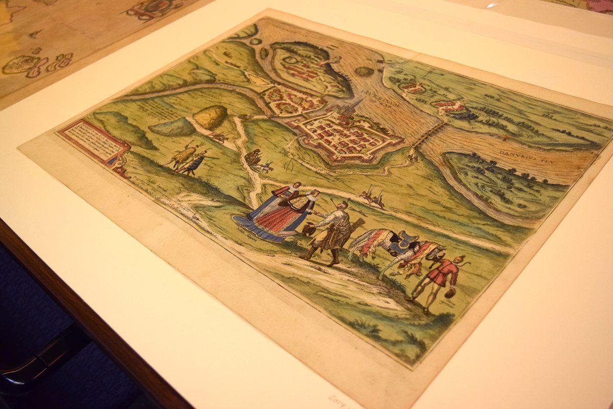
As a UT alumna and scholar who focuses on 17th century Flemish artwork, Waugh said one of her favorite prints in the collection is a 1598 print from Cologne, Germany, emphasizing its use as a map and a “genre image,” or illustration of daily life.
“In the foreground, it has a group of figures who are conversing, who are obviously traveling, so there’s this kind of multi-dimensional element of that map that’s giving us information about the landscape and about the city that’s being depicted,” Waugh said. “But [it] is also giving us information about these figures, and there’s kind of a narrative element to it.”
Although these maps were not sought by the museum, Waugh said their integration into McClung’s collection has spread the word on campus about the museum’s availability of academic tools and resources for students and faculty.